995
WTPA35 PHFO 120601
TCPCP5
BULLETIN
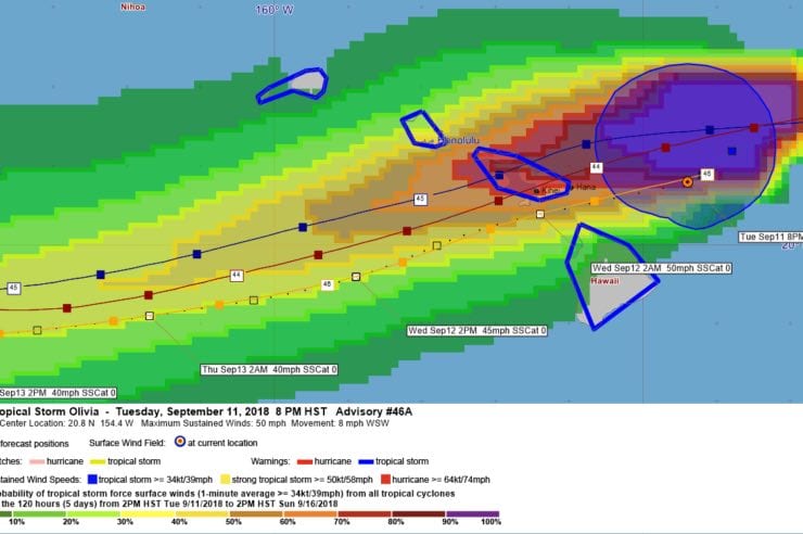
Tropical Storm Olivia Intermediate Advisory Number 46A
NWS Central Pacific Hurricane Center Honolulu HI EP172018
800 PM HST Tue Sep 11 2018
…OLIVIA SLOWS DOWN BUT STILL MOVING TOWARD MAUI COUNTY AND THE BIG
ISLAND…
SUMMARY OF 800 PM HST…0600 UTC…INFORMATION
———————————————-
LOCATION…20.8N 154.4W
ABOUT 85 MI…135 KM NE OF HILO HAWAII
ABOUT 230 MI…370 KM E OF HONOLULU HAWAII
MAXIMUM SUSTAINED WINDS…50 MPH…85 KM/H
PRESENT MOVEMENT…SW OR 235 DEGREES AT 8 MPH…13 KM/H
MINIMUM CENTRAL PRESSURE…1003 MB…29.62 INCHES
WATCHES AND WARNINGS
——————–
CHANGES WITH THIS ADVISORY:
None.
SUMMARY OF WATCHES AND WARNINGS IN EFFECT:
A Tropical Storm Warning is in effect for…
* Kauai County…including the islands of Kauai and Niihau
* Oahu
* Maui County…including the islands of Maui, Molokai, Lanai, and
Kahoolawe
* Hawaii County
Interests in the Northwest Hawaiian Islands should monitor the
progress of Olivia.
A Tropical Storm Warning means that tropical storm conditions are
expected somewhere in the warning area within 36 hours.
For storm information specific to your area, please monitor
products issued by the National Weather Service office in
Honolulu Hawaii.
DISCUSSION AND OUTLOOK
———————-
At 800 PM HST (0600 UTC), the center of Tropical Storm Olivia was
located near latitude 20.8 North, longitude 154.4 West. Olivia’s
forward speed has slowed once again, and it is moving toward the
southwest near 8 mph (13 km/h). A general west-southwest motion and
a gradual increase in forward speed is expected overnight as the
center of Olivia approaches Maui and the Big Island. After Olivia
moves past the islands, a somewhat faster west-southwest motion is
expected to resume and continue for the next couple of days.
Maximum sustained winds are near 50 mph (85 km/h) with higher
gusts. Gradual weakening is forecast during the next 48 hours, but
Olivia is expected to remain a tropical storm as it moves over the
main Hawaiian Islands.
Tropical-storm-force winds extend outward up to 105 miles (165 km),
mainly to the north of the center.
The estimated minimum central pressure is 1003 mb (29.62 inches).
HAZARDS AFFECTING LAND
———————-
WIND: Tropical storm conditions are expected over portions of
Maui County and the Big Island starting tonight. Tropical
storm conditions are expected to begin over Oahu early Wednesday.
Tropical storm conditions are expected over Kauai County starting
later Wednesday. Remember that wind gusts can be much stronger near
higher terrain, particularly through gaps between mountains and
where winds blow downslope.
RAINFALL: Showers will continue to increase over portions of the
main Hawaiian Islands tonight and Wednesday. Olivia is expected to
produce total rainfall accumulations of 5 to 10 inches in some
areas, with isolated maximum amounts of 15 inches possible,
especially in higher terrain. This rainfall may produce
life-threatening flash flooding.
SURF: Large swells generated by Olivia will impact the main Hawaiian
Islands over the next couple of days. This will result in
dangerously high and potentially damaging surf, mainly along
exposed east facing shores.
NEXT ADVISORY
————-
Next complete advisory at 1100 PM HST.
$$
Forecaster Birchard
535
WTPA45 PHFO 120312
TCDCP5
Tropical Storm Olivia Discussion Number 46
NWS Central Pacific Hurricane Center Honolulu HI EP172018
500 PM HST Tue Sep 11 2018
Olivia’s low level circulation center (LLCC) continues to outrun
the bands of deep convection now well to the east of the center.
Without any new deep convection near the center, the wind field
continues to gradually spin down. However, the 53rd Weather
Reconnaissance Squadron found SFMR winds of 42 kt in the northeast
quadrant. Thus, the current intensity has been lowered to 45 kt for
this advisory. This also agrees well with an earlier 1939 UTC ASCAT
pass that covered part of the tropical cyclone.
The motion has been very erratic today. As the LLCC decoupled from
the deep convection, it accelerated rapidly westward. Since about
2000 UTC, this motion has been quite a bit slower and toward the
southwest. Averaging this out to a representative motion gives
260/13. Erratic motion is likely to continue overnight as the now
shallow circulation of Olivia encounters terrain, but a general
west-southwest motion is expected. If Olivia’s LLCC survives the
passage near the island terrain (and this is a big if), the center
is expected to continue moving toward the west-southwest through 48
hours. A more westward motion is expected to begin by 72 hours and
beyond as the deep layer ridge west of Olivia weakens and an mid-
level low digs southwest toward the cyclone.
Our intensity forecast operates under the assumption that the low
level circulation center will be intact after emerging to the
southwest of Maui and the Big Island. If this occurs, gradual
weakening is expected to continue in line with all the guidance
which shows moderate to strong shear continuing through the
forecast period. Olivia is expected to become a remnant low within
72 hours, but there is a decent chance this will happen even
sooner.
Key Messages:
1. As Olivia moves across the main Hawaiian Islands, it still bring
worse impacts than recent Hurricane Lane to some areas. Those
impacts could include flooding rainfall, damaging winds, and
large and dangerous surf.
2. Significant impacts can occur well away from the center. In
particular, the mountainous terrain of Hawaii can produce localized
areas of strongly enhanced wind gusts and rainfall.
FORECAST POSITIONS AND MAX WINDS
INIT 12/0300Z 20.9N 154.2W 45 KT 50 MPH
12H 12/1200Z 20.4N 156.4W 45 KT 50 MPH
24H 13/0000Z 19.6N 158.9W 40 KT 45 MPH
36H 13/1200Z 19.1N 161.7W 35 KT 40 MPH
48H 14/0000Z 18.8N 164.7W 35 KT 40 MPH
72H 15/0000Z 19.0N 169.0W 30 KT 35 MPH…POST-TROP/REMNT LOW
96H 16/0000Z 19.8N 172.7W 30 KT 35 MPH…POST-TROP/REMNT LOW
120H 17/0000Z 20.9N 176.0W 30 KT 35 MPH…POST-TROP/REMNT LOW
$$
Forecaster R Ballard


Leave a Reply