000
WTPZ35 KNHC 162031
TCPEP5
BULLETIN
HURRICANE DARBY ADVISORY NUMBER 21
NWS NATIONAL HURRICANE CENTER MIAMI FL EP052016
200 PM PDT SAT JUL 16 2016
…DARBY UNEXPECTEDLY BECOMES A MAJOR HURRICANE…
SUMMARY OF 200 PM PDT…2100 UTC…INFORMATION
———————————————-
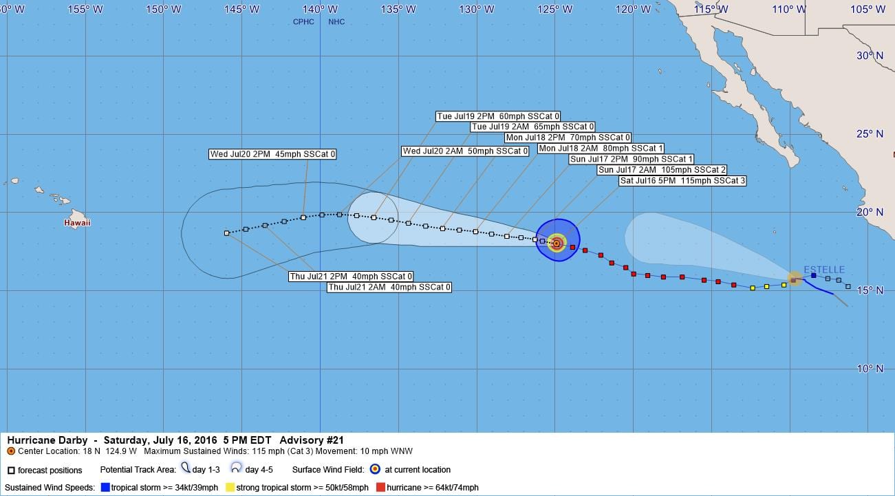
LOCATION…18.0N 124.9W
ABOUT 1025 MI…1655 KM WSW OF THE SOUTHERN TIP OF BAJA CALIFORNIA
MAXIMUM SUSTAINED WINDS…115 MPH…185 KM/H
PRESENT MOVEMENT…WNW OR 285 DEGREES AT 10 MPH…17 KM/H
MINIMUM CENTRAL PRESSURE…962 MB…28.41 INCHES
WATCHES AND WARNINGS
——————–
There are no coastal watches or warnings in effect.
DISCUSSION AND 48-HOUR OUTLOOK
——————————
At 200 PM PDT (2100 UTC), the eye of Hurricane Darby was located
near latitude 18.0 North, longitude 124.9 West. Darby is moving
toward the west-northwest near 10 mph (17 km/h). A westward or
west-northwestward motion at a similar forward speed is expected
during the next few of days.
Maximum sustained winds have increased to near 115 mph (185 km/h)
with higher gusts. Darby is a category 3 hurricane on the
Saffir-Simpson Hurricane Wind Scale. Gradual weakening is forecast
during the next 48 hours, and Darby could lose hurricane intensity
on Monday.
Hurricane-force winds extend outward up to 30 miles (45 km) from the
center, and tropical-storm-force winds extend outward up to 115
miles (185 km).
The estimated minimum central pressure is 962 mb (28.41 inches).
HAZARDS AFFECTING LAND
———————-
None.
NEXT ADVISORY
————-
Next complete advisory at 800 PM PDT.
$$
Forecaster Berg
000
WTPZ45 KNHC 162033
TCDEP5
HURRICANE DARBY DISCUSSION NUMBER 21
NWS NATIONAL HURRICANE CENTER MIAMI FL EP052016
200 PM PDT SAT JUL 16 2016
Darby appears to have been strengthening during the day despite
moving over increasingly cooler waters. The deep convection is
becoming more symmetric, the eye has been warming intermittently,
and the hurricane appears to be losing some of its outer banding.
In fact, Darby has developed a marginal annular structure. Dvorak
estimates have generally risen since this morning, and the initial
intensity is raised to 100 kt. This makes Darby the second major
hurricane of the eastern North Pacific season.
Sea surface temperatures beneath Darby are currently around 25.5C
and will continue to decrease over the next few days. But, given
that vertical shear is expected to remain low through at least day
3, and the hurricane’s marginal annular structure, Darby is likely
to remain relatively steady in intensity or only gradually weaken in
the short-term. Faster weakening is still expected later in the
forecast period due to the added effect of increasing shear.
Almost every reliable intensity model shows Darby weakening fast
during the next day or two. However, the HWRF model is a notable
outlier and keeps Darby as a hurricane at least through day 3. The
updated NHC intensity forecast is a little higher than the previous
forecast during the first 36 hours and is near the top end of the
main pack of intensity models.
The initial motion remains 285/9 kt. The subtropical ridge to the
north of Darby is weakening, but it should stay strong enough to
steer the hurricane west-northwestward or westward through the
entire forecast period. The new run of the ECMWF has sped up
compared to the other track models, but otherwise there is very
little spread in the guidance envelope. The updated NHC track
forecast is closest to an average of the GFS and ECMWF and is very
close to the previous forecast.
FORECAST POSITIONS AND MAX WINDS
INIT 16/2100Z 18.0N 124.9W 100 KT 115 MPH
12H 17/0600Z 18.3N 126.3W 90 KT 105 MPH
24H 17/1800Z 18.5N 128.1W 80 KT 90 MPH
36H 18/0600Z 18.8N 130.1W 70 KT 80 MPH
48H 18/1800Z 19.0N 132.2W 60 KT 70 MPH
72H 19/1800Z 19.7N 136.6W 50 KT 60 MPH
96H 20/1800Z 19.7N 141.1W 40 KT 45 MPH
120H 21/1800Z 18.7N 146.0W 35 KT 40 MPH
$$
Forecaster Berg


Leave a Reply