000
WTPZ33 KNHC 100232
TCPEP3
BULLETIN
TROPICAL STORM BLAS ADVISORY NUMBER 29
NWS NATIONAL HURRICANE CENTER MIAMI FL EP032016
800 PM PDT SAT JUL 09 2016
…BLAS WEAKENING FAST OVER COLD WATERS…
SUMMARY OF 800 PM PDT…0300 UTC…INFORMATION
———————————————-
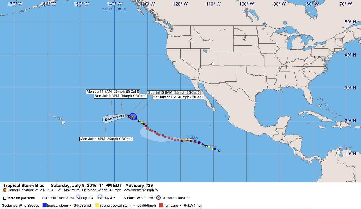
LOCATION…21.2N 134.5W
ABOUT 1335 MI…2150 KM E OF HILO HAWAII
MAXIMUM SUSTAINED WINDS…40 MPH…65 KM/H
PRESENT MOVEMENT…W OR 280 DEGREES AT 12 MPH…19 KM/H
MINIMUM CENTRAL PRESSURE…1003 MB…29.62 INCHES
WATCHES AND WARNINGS
——————–
There are no coastal watches or warnings in effect.
DISCUSSION AND 48-HOUR OUTLOOK
——————————
At 800 PM PDT (0300 UTC), the center of Tropical Storm Blas was
located near latitude 21.2 North, longitude 134.5 West. Blas is
moving toward the west near 12 mph (19 km/h), and this general
motion is expected to continue during the next couple of days.
Maximum sustained winds have decreased to near 40 mph (65 km/h)
with higher gusts. Blas is forecast to become a remnant low on
Sunday.
Tropical-storm-force winds extend outward up to 80 miles (130 km)
from the center.
The estimated minimum central pressure is 1003 mb (29.62 inches).
HAZARDS AFFECTING LAND
———————-
None.
NEXT ADVISORY
————-
Next complete advisory at 200 AM PDT.
$$
Forecaster Avila
000
WTPZ43 KNHC 100233
TCDEP3
TROPICAL STORM BLAS DISCUSSION NUMBER 29
NWS NATIONAL HURRICANE CENTER MIAMI FL EP032016
800 PM PDT SAT JUL 09 2016
The cloud pattern has degraded significantly tonight, and the
deep convection has practically vanished. However, given the
vigorous circulation still associated with Blas, it is estimated
that the winds are 35 kt. Due to cold waters and high shear, global
models and the intensity guidance weaken the cyclone fast. On this
basis, the NHC forecast calls for Blas to degenerate into a remnant
low in 24 hours or less.
Blas’ circulation is moving toward the west or 280 degrees at 10
kt. Now that the cyclone is quickly becoming a shallow system, it is
forecast to be steered westward or west-southwestward by the
low-level flow until dissipation in a couple of days. Blas could
still produce sporadic bursts of convection in the next day or two.
FORECAST POSITIONS AND MAX WINDS
INIT 10/0300Z 21.2N 134.5W 35 KT 40 MPH
12H 10/1200Z 21.5N 136.0W 30 KT 35 MPH
24H 11/0000Z 21.5N 138.1W 25 KT 30 MPH…POST-TROP/REMNT LOW
36H 11/1200Z 21.0N 140.5W 20 KT 25 MPH…POST-TROP/REMNT LOW
48H 12/0000Z 20.5N 142.5W 20 KT 25 MPH…POST-TROP/REMNT LOW
72H 13/0000Z…DISSIPATED
$$
Forecaster Avila


Leave a Reply