000
WTPZ34 KNHC 100233
TCPEP4
BULLETIN
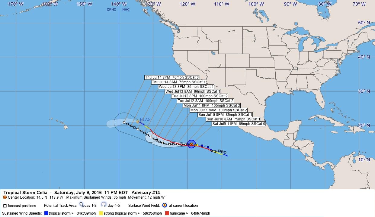
TROPICAL STORM CELIA ADVISORY NUMBER 14
NWS NATIONAL HURRICANE CENTER MIAMI FL EP042016
800 PM PDT SAT JUL 09 2016
…CELIA FORECAST TO BECOME A HURRICANE SUNDAY MORNING…
SUMMARY OF 800 PM PDT…0300 UTC…INFORMATION
———————————————-
LOCATION…14.5N 118.9W
ABOUT 825 MI…1330 KM SW OF THE SOUTHERN TIP OF BAJA CALIFORNIA
MAXIMUM SUSTAINED WINDS…65 MPH…100 KM/H
PRESENT MOVEMENT…W OR 275 DEGREES AT 12 MPH…19 KM/H
MINIMUM CENTRAL PRESSURE…994 MB…29.36 INCHES
WATCHES AND WARNINGS
——————–
There are no coastal watches or warnings in effect.
DISCUSSION AND 48-HOUR OUTLOOK
——————————
At 800 PM PDT (0300 UTC), the center of Tropical Storm Celia was
located near latitude 14.5 North, longitude 118.9 West. Celia is
moving toward the west near 12 mph (19 km/h), and this motion is
expected to continue through Monday.
Maximum sustained winds are near 65 mph (100 km/h) with higher
gusts. Strengthening is forecast during the next 48 hours, and
Celia is expected to become a hurricane Sunday morning.
Tropical-storm-force winds extend outward up to 90 miles (150 km)
from the center.
The estimated minimum central pressure is 994 mb (29.36 inches).
HAZARDS AFFECTING LAND
———————-
None.
NEXT ADVISORY
————-
Next complete advisory at 200 AM PDT.
$$
Forecaster Berg
000
WTPZ44 KNHC 100233
TCDEP4
TROPICAL STORM CELIA DISCUSSION NUMBER 14
NWS NATIONAL HURRICANE CENTER MIAMI FL EP042016
800 PM PDT SAT JUL 09 2016
Celia has changed very little since the last advisory. A small
central dense overcast persists over the low-level center, with an
elongated convective band wrapping around the southern and western
side of the circulation. The initial intensity remains 55 kt based
on Dvorak estimates of T3.5 from TAFB and SAB. Celia appears to
have escaped the coldest water of Hurricane Blas’s wake and is now
over sea surface temperatures warmer than 27 degrees Celsius. In
addition, vertical shear is very low and is expected to remain low
for the next 5 days. Therefore, more significant strengthening
(compared to the past few days) should begin soon and continue
during the next 2 to 3 days while the cyclone is over warm water. A
gradual weakening trend should occur on day 3 and beyond. The NHC
intensity forecast is close to a blend of the SHIPS and LGEM
models and is very similar to the previous forecast.
Celia’s initial motion is westward, or 275/10 kt. A continued
westward motion is expected for the next 48 hours while the cyclone
is located south of the subtropical ridge. By day 3, Celia will be
situated along the southwestern periphery of the ridge and should
turn west-northwestward and northwestward at the end of the forecast
period. The track guidance continues to be relatively stable and
tightly clustered from cycle to cycle, and the new NHC track
forecast is just an update of the previous one.
FORECAST POSITIONS AND MAX WINDS
INIT 10/0300Z 14.5N 118.9W 55 KT 65 MPH
12H 10/1200Z 14.5N 120.6W 65 KT 75 MPH
24H 11/0000Z 14.6N 123.0W 75 KT 85 MPH
36H 11/1200Z 14.6N 125.3W 85 KT 100 MPH
48H 12/0000Z 15.0N 127.3W 90 KT 105 MPH
72H 13/0000Z 16.7N 130.7W 85 KT 100 MPH
96H 14/0000Z 19.0N 134.5W 75 KT 85 MPH
120H 15/0000Z 21.0N 138.5W 60 KT 70 MPH
$$
Forecaster Berg


Leave a Reply