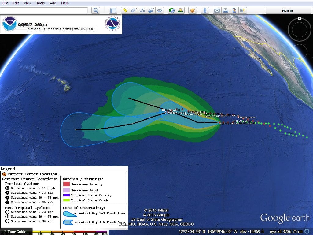
Tropical Storm Gil Crossing Depression Eight E
08032013
Google Earth Visualization
The following image was rendered from real time data Please
note these GIS data are experimental. National Weather
Service Gil and Eight-E Sunday
morning The image above was created using realtime data
from The National Weather Service KMZ file.
000 WTPZ33 KNHC 040849
TCPEP3 BULLETIN TROPICAL DEPRESSION EIGHT-E ADVISORY NUMBER 4 NWS
NATIONAL HURRICANE CENTER MIAMI FL EP082013 200 AM PDT SUN AUG 04
2013 ...DEPRESSION CONTINUES MOVING WESTWARD... SUMMARY OF 200 AM
PDT...0900 UTC...INFORMATION
---------------------------------------------- LOCATION...12.8N
125.6W ABOUT 1245 MI...2005 KM WSW OF THE SOUTHERN TIP OF BAJA
CALIFORNIA MAXIMUM SUSTAINED WINDS...35 MPH...55 KM/H PRESENT
MOVEMENT...W OR 270 DEGREES AT 9 MPH...15 KM/H MINIMUM CENTRAL
PRESSURE...1008 MB...29.77 INCHES WATCHES AND WARNINGS
-------------------- THERE ARE NO COASTAL WATCHES OR WARNINGS IN
EFFECT. DISCUSSION AND 48-HOUR OUTLOOK
------------------------------ AT 200 AM PDT...0900 UTC...THE
CENTER OF TROPICAL DEPRESSION EIGHT-E WAS LOCATED NEAR LATITUDE
12.8 NORTH...LONGITUDE 125.6 WEST. THE DEPRESSION IS MOVING TOWARD
THE WEST NEAR 9 MPH...15 KM/H. THIS GENERAL MOTION IS EXPECTED TO
CONTINUE FOR THE NEXT DAY OR SO... FOLLOWED BY A TURN TOWARD THE
WEST-NORTHWEST ON MONDAY. MAXIMUM SUSTAINED WINDS ARE NEAR 35
MPH...55 KM/H...WITH HIGHER GUSTS. SOME STRENGTHENING IS FORECAST
DURING THE NEXT 48 HOURS... AND THE DEPRESSION IS EXPECTED TO
BECOME A TROPICAL STORM LATER TODAY. THE ESTIMATED MINIMUM CENTRAL
PRESSURE IS 1008 MB...29.77 INCHES. HAZARDS AFFECTING LAND
---------------------- NONE. NEXT ADVISORY ------------- NEXT
COMPLETE ADVISORY...800 AM PDT. $$ FORECASTER STEWART
000 WTPZ32
KNHC 040849 TCPEP2 BULLETIN TROPICAL STORM GIL ADVISORY NUMBER 20
NWS NATIONAL HURRICANE CENTER MIAMI FL EP072013 200 AM PDT SUN AUG
04 2013 ...GIL QUICKLY FALLING APART... SUMMARY OF 200 AM
PDT...0900 UTC...INFORMATION
---------------------------------------------- LOCATION...14.6N
135.2W ABOUT 1360 MI...2185 KM ESE OF HILO HAWAII ABOUT 1750
MI...2815 KM WSW OF THE SOUTHERN TIP OF BAJA CALIFORNIA MAXIMUM
SUSTAINED WINDS...40 MPH...65 KM/H PRESENT MOVEMENT...WSW OR 250
DEGREES AT 9 MPH...15 KM/H MINIMUM CENTRAL PRESSURE...1006
MB...29.71 INCHES WATCHES AND WARNINGS -------------------- THERE
ARE NO COASTAL WATCHES OR WARNINGS IN EFFECT. DISCUSSION AND
48-HOUR OUTLOOK ------------------------------ AT 200 AM PDT...0900
UTC...THE CENTER OF TROPICAL STORM GIL WAS LOCATED NEAR LATITUDE
14.6 NORTH...LONGITUDE 135.2 WEST. GIL IS MOVING TOWARD THE
WEST-SOUTHWEST NEAR 9 MPH...15 KM/H...AND THIS MOTION IS EXPECTED
TO CONTINUE DURING THE NEXT 48 HOURS. MAXIMUM SUSTAINED WINDS HAVE
DECREASED TO NEAR 40 MPH...65 KM/H... WITH HIGHER GUSTS. ADDITIONAL
WEAKENING IS EXPECTED DURING THE NEXT COUPLE OF DAYS...AND GIL
COULD BECOME A REMNANT LOW AS EARLY AS LATER TODAY.
TROPICAL-STORM-FORCE WINDS EXTEND OUTWARD UP TO 60 MILES...95 KM
FROM THE CENTER. THE ESTIMATED MINIMUM CENTRAL PRESSURE IS 1006
MB...29.71 INCHES. HAZARDS AFFECTING LAND ----------------------
NONE. NEXT ADVISORY ------------- NEXT COMPLETE ADVISORY...800 AM
PDT. $$ FORECASTER BERG


Leave a Reply