Tropical Storm Lala tracked northwest through the Hawaiian Islands on August 15–16, 2026, bringing hurricane-force winds, heavy rainfall, life-threatening flooding, mudslides, and dangerous surf. A Hurricane Warning was issued for Hawaiʻi County, with Tropical Storm Warnings in effect for Maui, Oʻahu, and Kauaʻi Counties.
By the afternoon of August 16, Lala had weakened to 65 mph sustained winds and was moving westward roughly 170 miles from Lihue. Rainfall totals of up to 40 inches were recorded on the windward Big Island, with storm surge of 1–2 feet and continued dangerous surf expected across the island chain into early the following week.
Live Satellite View
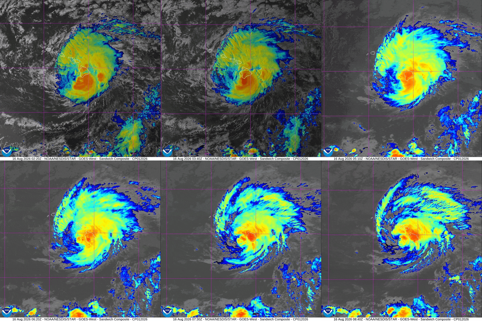
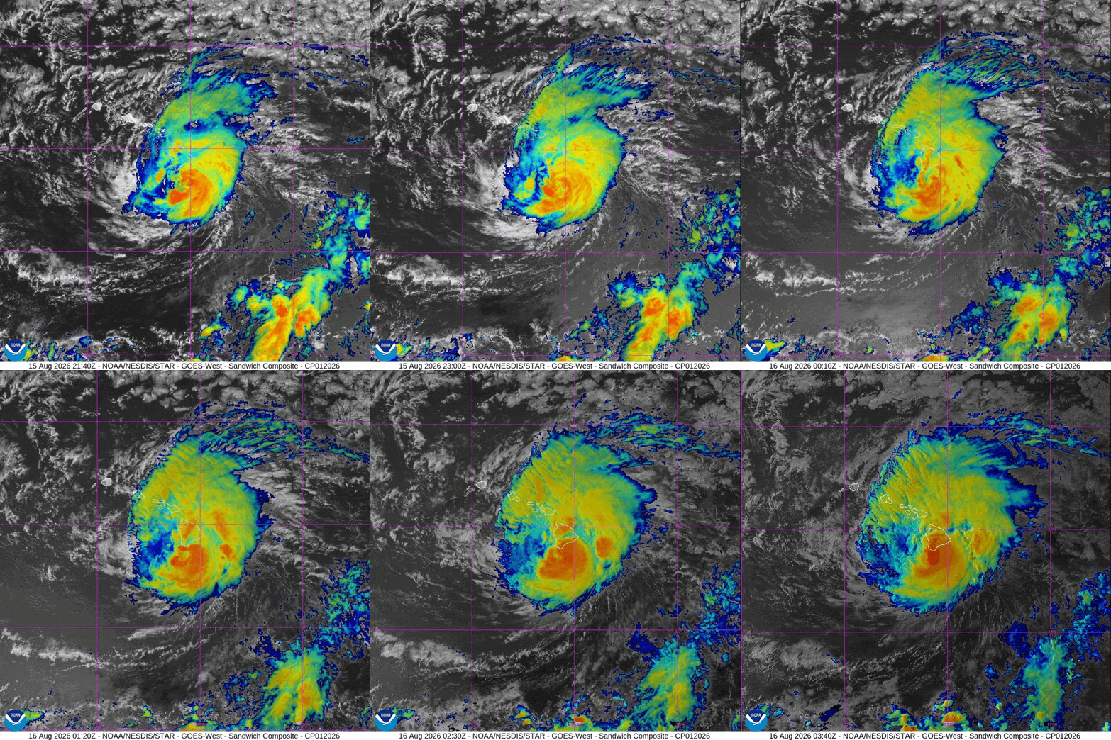
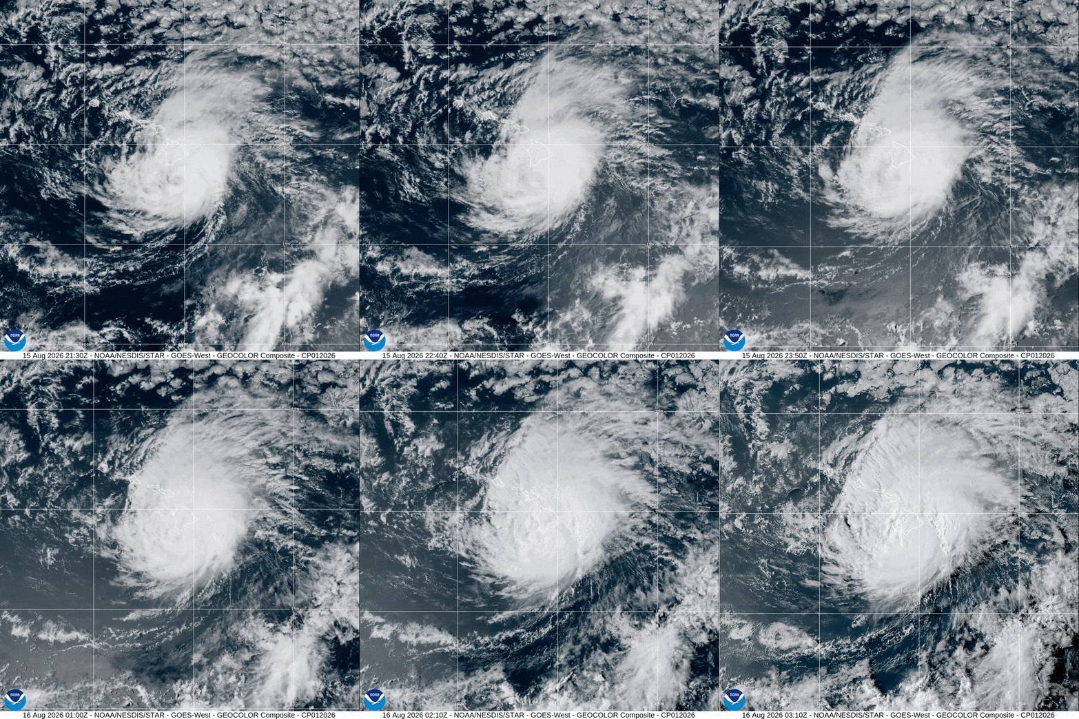
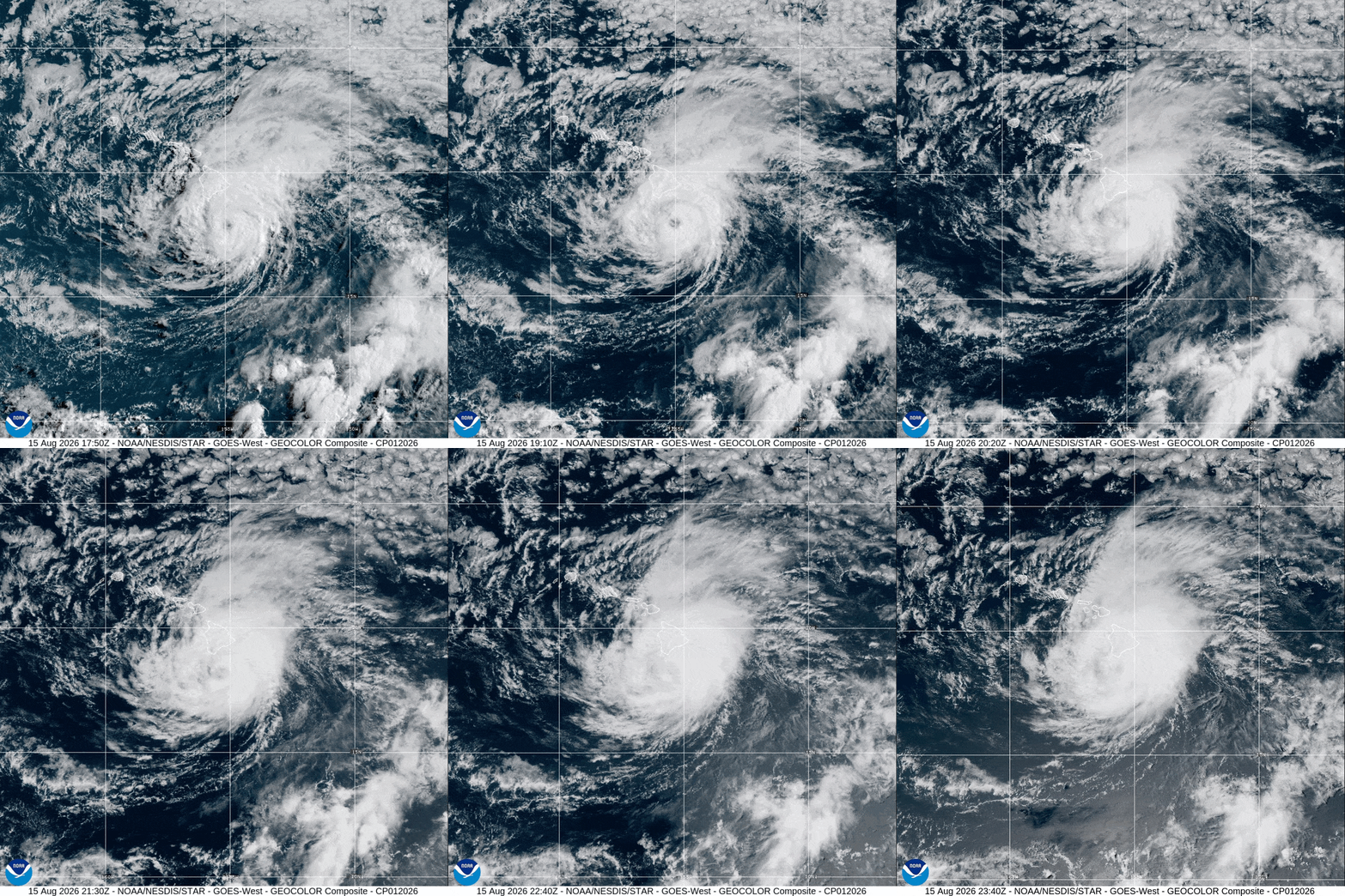
The live satellite image below shows current cloud activity across the Pacific and near Hawaiʻi. It is updated approximately every five minutes and can help provide a visual view of the storm’s structure and surrounding weather conditions.

Live imagery: NOAA/CIRA GOES-West
This live update had tracked Tropical Storm Lala near Hawaii. It explained the storm’s latest satellite appearance, possible impacts, and official safety information for residents and visitors across the Hawaiian Islands. Tracking and updates are completed
Archive of Updates — Hurricane Lala
BULLETIN
Tropical Storm Lala Advisory Number  19
NWS Central Pacific Hurricane Center Honolulu HI   CP012026
Issued by NWS National Hurricane Center Miami FL
500 PM HST Sun Aug 16 2026

...LALA HOLDING STEADY SOUTHWEST OF KAUAI COUNTY...
...OUTER BANDS OF LALA BRINGING HEAVY RAINFALL AND GUSTY WINDS TO
PORTIONS OF THE MAIN HAWAIIAN ISLANDS...


SUMMARY OF 500 PM HST...0300 UTC...INFORMATION
----------------------------------------------
LOCATION...20.7N 161.6W
ABOUT 240 MI...390 KM W OF HONOLULU HAWAII
ABOUT 170 MI...270 KM WSW OF LIHUE HAWAII
MAXIMUM SUSTAINED WINDS...65 MPH...100 KM/H
PRESENT MOVEMENT...W OR 265 DEGREES AT 16 MPH...26 KM/H
MINIMUM CENTRAL PRESSURE...994 MB...29.36 INCHES


WATCHES AND WARNINGS
--------------------
CHANGES WITH THIS ADVISORY:

None.

SUMMARY OF WATCHES AND WARNINGS IN EFFECT:

A Tropical Storm Warning is in effect for...
* Kauai County, including the islands of Kauai and Niihau

A Tropical Storm Warning means that tropical storm conditions are
expected somewhere within the warning area, in this case within the
next 12 hours.

Interests in the Papahanaumokuakea Marine National Monument should
monitor the progress of Lala.

For storm information specific to your area, including possible
inland watches and warnings, please monitor products issued by your
local National Weather Service forecast office.


DISCUSSION AND OUTLOOK
----------------------
At 500 PM HST (0300 UTC), the center of Tropical Storm Lala was
located near latitude 20.7 North, longitude 161.6 West. Lala is
moving toward the west near 16 mph (26 km/h). A westward motion is
forecast through Tuesday, followed by a turn toward the
west-northwest on Wednesday.

Maximum sustained winds are near 65 mph (100 km/h) with higher
gusts. Little intensity change is expected over the next day or
two. Some restrengthening is forecast thereafter, and Lala could
become a hurricane again by Wednesday.

Tropical-storm-force winds extend outward up to 140 miles (220 km)
from the center.

The estimated minimum central pressure is 994 mb (29.36 inches).


HAZARDS AFFECTING LAND
----------------------
Key messages for Lala can be found in the Tropical Cyclone
Discussion under AWIPS header HFOTCDCP2 and WMO header WTPA42 PHFO.

WIND: Tropical storm conditions, especially in gusts, are ongoing
across portions of Kauai County, with the strongest winds occurring
in areas of higher terrain. Wind speeds atop mountains and on the
windward and leeward slopes are often up to 30 percent stronger than
the near-surface winds indicated in this advisory, and in some
elevated locations could be even greater.

RAINFALL: Outer bands from Lala are expected to produce additional
rainfall of 1 to 2 inches across windward portions of the Big Island
and windward Maui, with maximum storm totals of 30 to 40 inches over
the windward Big Island. Across the remainder of the island chain an
additional 2 to 4 inches of rainfall is expected, with isolated
additional totals around 6 inches. This rainfall may produce
flooding and mudslides, especially in areas of steep terrain.

For a complete depiction of forecast rainfall associated with Lala,
please see the National Weather Service Storm Total Rainfall Graphic
available at hurricanes.gov/graphics_cp2.shtml?rainqpf

For a list of rainfall observations and wind reports associated with
Lala, see the companion storm summary at WBCSCCNS2 with the WMO
header ACUS42 KWBC or at the following link:
www.wpc.ncep.noaa.gov/discussions/nfdscc2.html.

STORM SURGE: Water levels may remain elevated through the next tide
cycle due to persistent large and dangerous wave activity.

SURF: Large waves generated by Lala will continue to impact exposed
waters of the Hawaiian Islands through tonight, with a gradual
downward trend expected from east to west by Monday.
Life-threatening surf and rip current conditions will continue.
Please consult products from your local weather office.



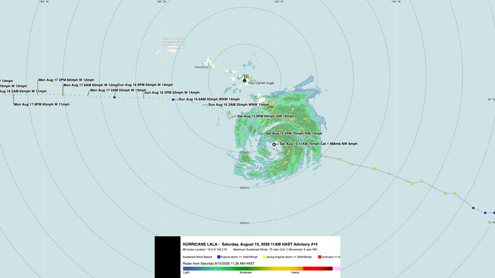

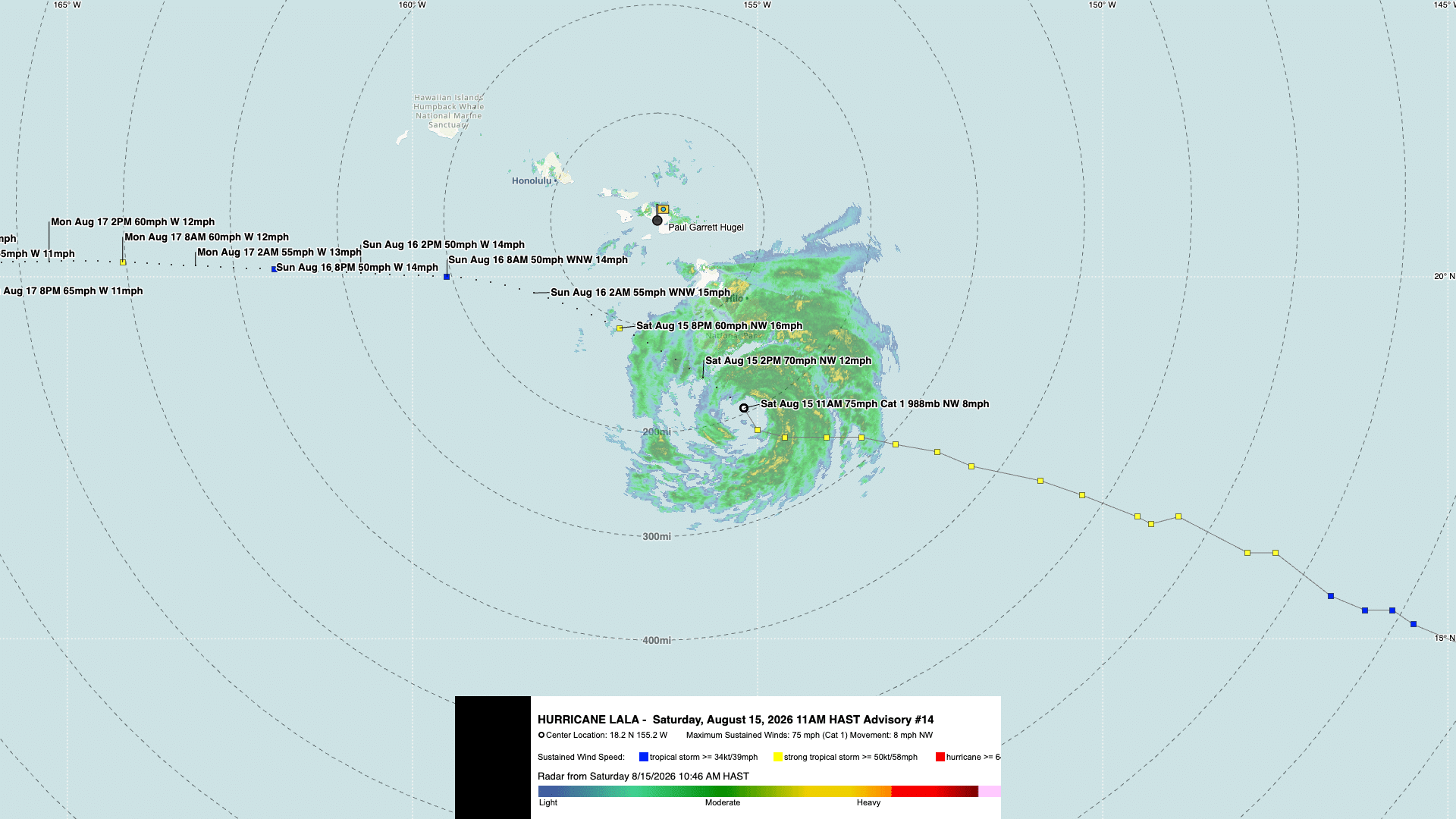

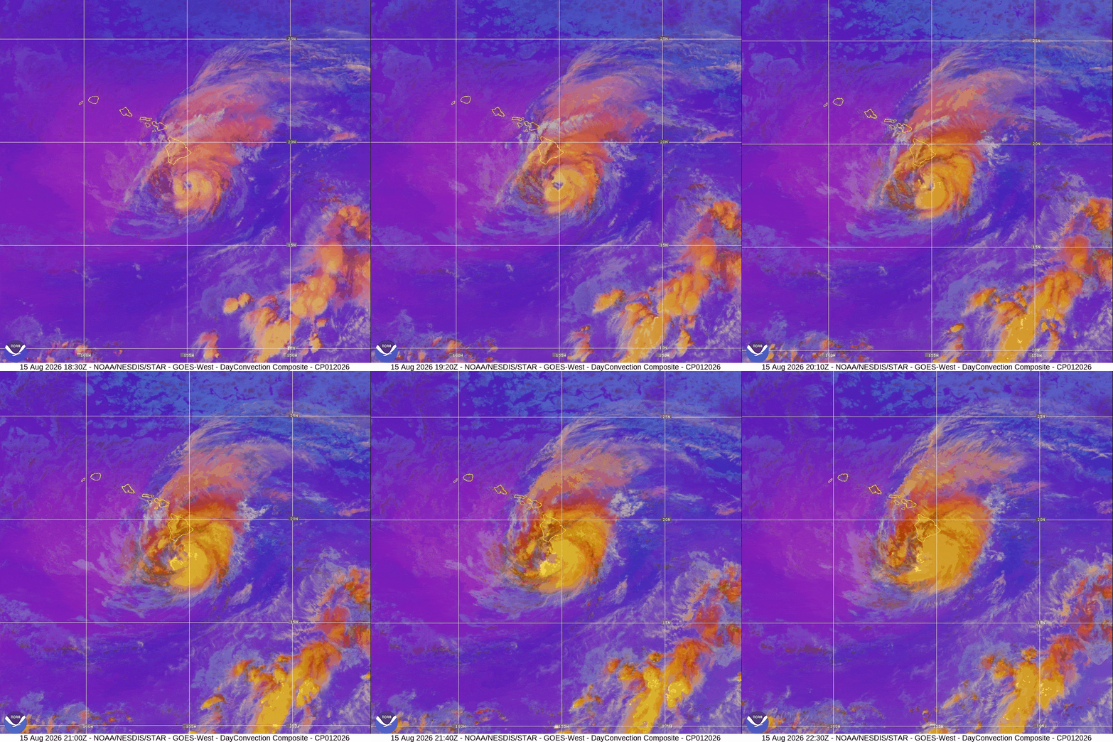
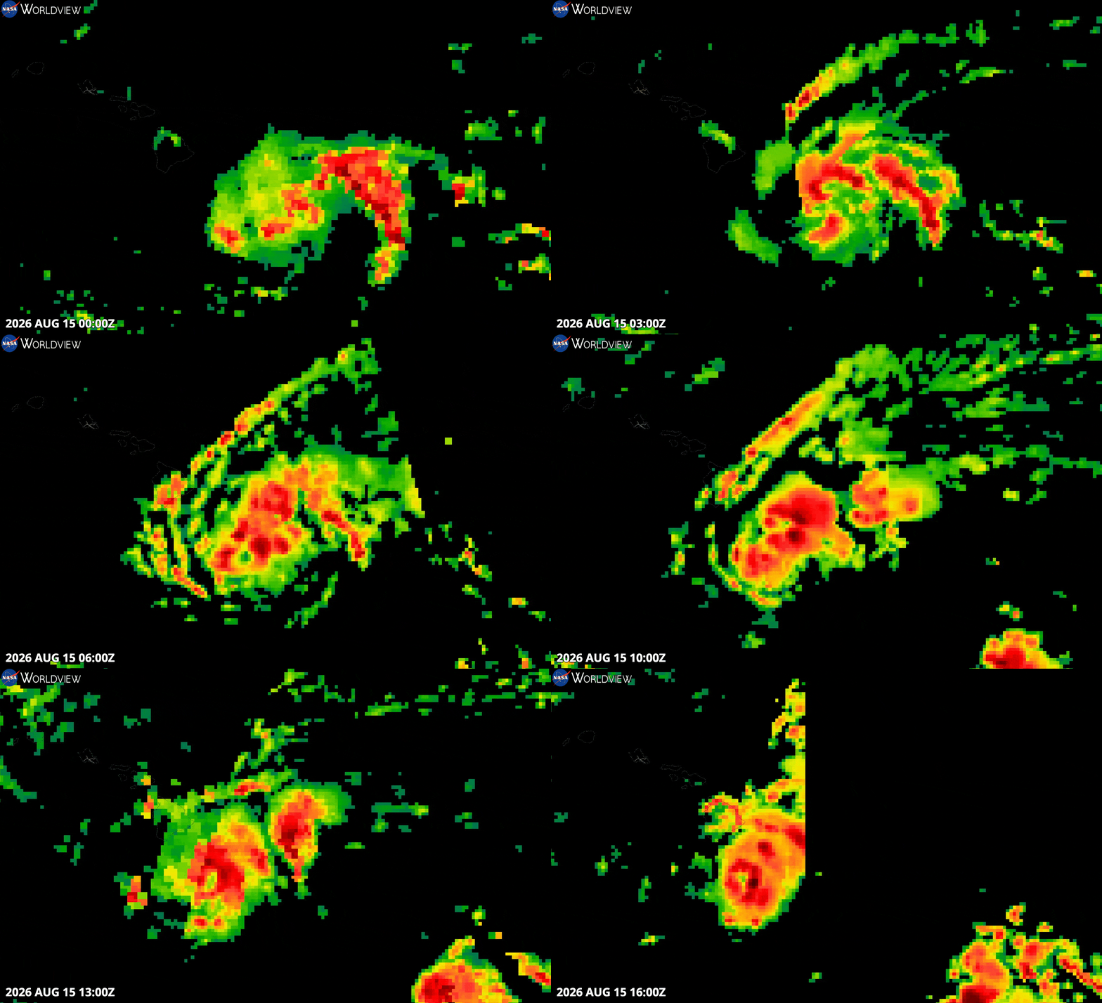
16 Aug 2026 – 8:00 AM HST
Tropical Storm Lala Intermediate Advisory Number 17A
BULLETIN
Tropical Storm Lala Intermediate Advisory Number 17A
NWS Central Pacific Hurricane Center Honolulu HI   CP012026
Issued by NWS National Hurricane Center Miami FL
800 AM HST Sun Aug 16 2026

...HEAVY RAINFALL AND GUSTY WINDS CONTINUE OVER PORTIONS OF MAUI
COUNTY AND OAHU...
...CONDITIONS DETERIORATING ACROSS KAUAI COUNTY...


SUMMARY OF 800 AM HST...1800 UTC...INFORMATION
----------------------------------------------
LOCATION...20.7N 158.8W
ABOUT 190 MI...305 KM WNW OF KAILUA-KONA HAWAII
ABOUT 75 MI...120 KM SW OF HONOLULU HAWAII
MAXIMUM SUSTAINED WINDS...65 MPH...100 KM/H
PRESENT MOVEMENT...NW OR 305 DEGREES AT 14 MPH...22 KM/H
MINIMUM CENTRAL PRESSURE...994 MB...29.36 INCHES


WATCHES AND WARNINGS
--------------------
CHANGES WITH THIS ADVISORY:

The Tropical Storm Warning for Hawaii County has been discontinued.

SUMMARY OF WATCHES AND WARNINGS IN EFFECT:

A Tropical Storm Warning is in effect for...
* Maui County, including the islands of Maui, Lanai, Molokai and
Kahoolawe
* Oahu
* Kauai County, including the islands of Kauai and Niihau

A Tropical Storm Warning means that tropical storm conditions are
expected somewhere within the warning area, in this case within the
next 12 hours.

Interests in the Papahanaumokuakea Marine National Monument should
monitor the progress of Lala.

For storm information specific to your area, including possible
inland watches and warnings, please monitor products issued by your
local National Weather Service forecast office.


DISCUSSION AND OUTLOOK
----------------------
At 800 AM HST (1800 UTC), the center of Tropical Storm Lala was
located near latitude 20.7 North, longitude 158.8 West. Lala is
moving toward the northwest near 14 mph (22 km/h) but is expected to
turn westward soon. Then, a continued westward motion is forecast
through Tuesday night. The center of the storm is forecast to pass
south of Kauai County today and move south of the easternmost
Northwestern Hawaiian Islands early this week.

Maximum sustained winds have decreased to near 65 mph (100 km/h)
with higher gusts. Slight additional weakening is possible during
the next day or so. Some restrengthening is forecast by midweek.

Tropical-storm-force winds extend outward up to 140 miles (220 km)
from the center. A wind gust of 67 mph (108 km/h) was recently
reported at the Marine Corps Air Station in Kaneohe (PHNG).

The estimated minimum central pressure is 994 mb (29.36 inches).


HAZARDS AFFECTING LAND
----------------------
Key messages for Lala can be found in the Tropical Cyclone
Discussion under AWIPS header HFOTCDCP2 and WMO header WTPA42 PHFO.

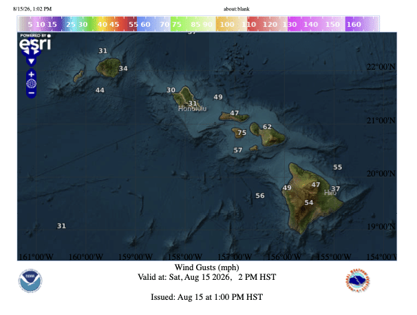
WIND: Tropical storm conditions are ongoing across portions of Maui
County and Oahu and are spreading westward over Kauai County, with
the strongest winds occurring in areas of higher terrain. Wind
speeds atop mountains and on the windward and leeward slopes are
often up to 30 percent stronger than the near-surface winds
indicated in this advisory, and in some elevated locations could be
even greater.

RAINFALL: Lala is expected to produce additional rainfall of 1 to 3
inches across windward portions of the the Big Island and windward
Maui, with maximum storm total of 30 to 35 inches over the windward
Big Island. Across the remainder of the island chain total rainfall
of 2 to 6 inches is expected, with the highest totals over windward
Kauai. This rainfall may produce life-threatening flooding and
mudslides, especially in areas of steep terrain.

For a complete depiction of forecast rainfall associated with Lala,
please see the National Weather Service Storm Total Rainfall Graphic
available at hurricanes.gov/graphics_cp2.shtml?rainqpf

For a list of rainfall observations and wind reports associated with
Lala, see the companion storm summary at WBCSCCNS2 with the WMO
header ACUS42 KWBC or at the following link:
www.wpc.ncep.noaa.gov/discussions/nfdscc2.html.

STORM SURGE: The combination of a dangerous storm surge and the
tide will cause normally dry areas near the coast to be flooded by
rising waters moving inland from the shoreline. The water could
reach the following heights above ground somewhere in the indicated
areas if the peak surge occurs at the time of high tide...

Oahu...1-2 ft
Kauai...1-2 ft

The deepest water will occur along the immediate coast, where the
surge will be accompanied by large and dangerous waves.
Surge-related flooding depends on the relative timing of the surge
and the tidal cycle, and can vary greatly over short distances. For
information specific to your area, please see products issued by
your local National Weather Service forecast office.

For a complete depiction of areas at risk of storm surge inundation,
please see the National Weather Service Peak Storm Surge Graphic,
available at hurricanes.gov/graphics_cp2.shtml?peakSurge.

SURF: Swells generated by Lala will continue to build westward
across the exposed windward waters today. Swells will also build
over the exposed leeward waters as Lala passes south of the islands.
These swells are likely to cause life-threatening surf and rip
current conditions. Please consult products from your local weather
office.
15 Aug 2026 – 11:00 PM HST
LALA REMAINS A HURRICANE AS IT BEGINS TO PULL AWAY FROM THE BIG ISLAND
DAMAGING WINDS AND HEAVY RAIN WILL PERSIST ACROSS THE BIG ISLAND AND MAUI COUNTY OVERNIGHT AND SPREAD WESTWARD ACROSS OAHU AND KAUAI COUNTY ON SUNDAY
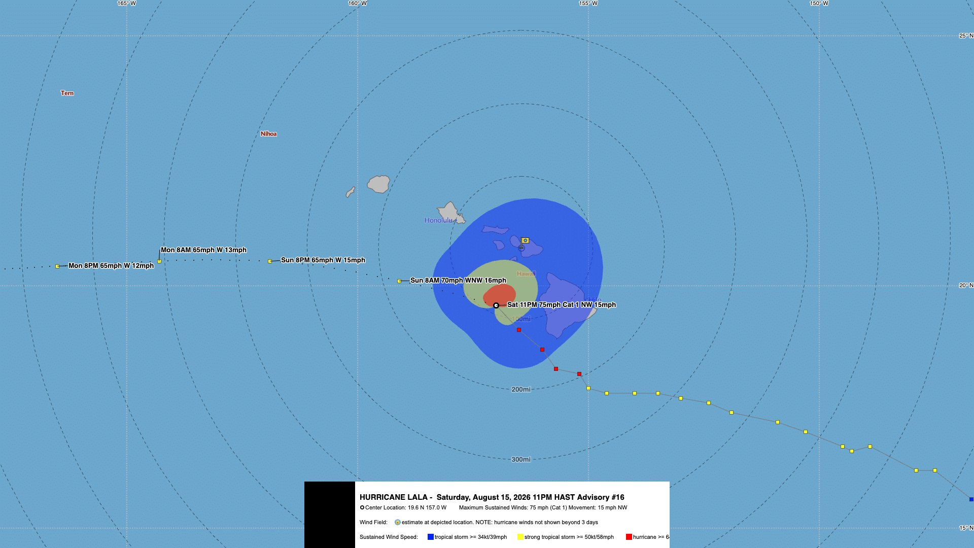
11:00 PM HST Saturday, August 15 position update:
- Center of Lala was located near 19.6°N, 157.0°W, about 65 miles west of Kailua-Kona and 130 miles south-southeast of Honolulu.
- Moving northwest at 15 mph.
- Minimum central pressure was 988 mb.
- Maximum sustained winds were 75 mph, with higher gusts.
- Hurricane Warning: Hawaii County.
- Tropical Storm Warning: Maui County, Oahu, and Kauai County.
Additional rainfall of 4 to 8 inches is expected across the Big Island and windward Maui, with life-threatening flooding and mudslides possible, especially in steep terrain. Dangerous surf and rip currents will persist across exposed waters.
Key Messages
- Damaging winds are expected to continue on the Big Island of Hawaii into the overnight hours, with the strongest wind gusts expected in areas of higher terrain. Residents are urged to stay in their shelter through tonight. Tropical-storm-force winds with gusts to near or up to hurricane strength will persist across portions of the smaller islands through Sunday.
- Heavy rainfall, with life-threatening flooding and mudslides, especially in areas of steep terrain, will continue tonight into early Sunday over the Big Island and Maui. This heavy rain and flood risk will continue to spread westward across the island chain through Sunday.
- Large and dangerous waves are expected to persist across portions of the Hawaiian Islands through the weekend. Surf is building along east-facing shores and will increase along exposed southern shores as Lala passes through the region. This heavy surf may cause localized coastal flooding and significant beach erosion.
FORECAST POSITIONS AND MAX WINDS
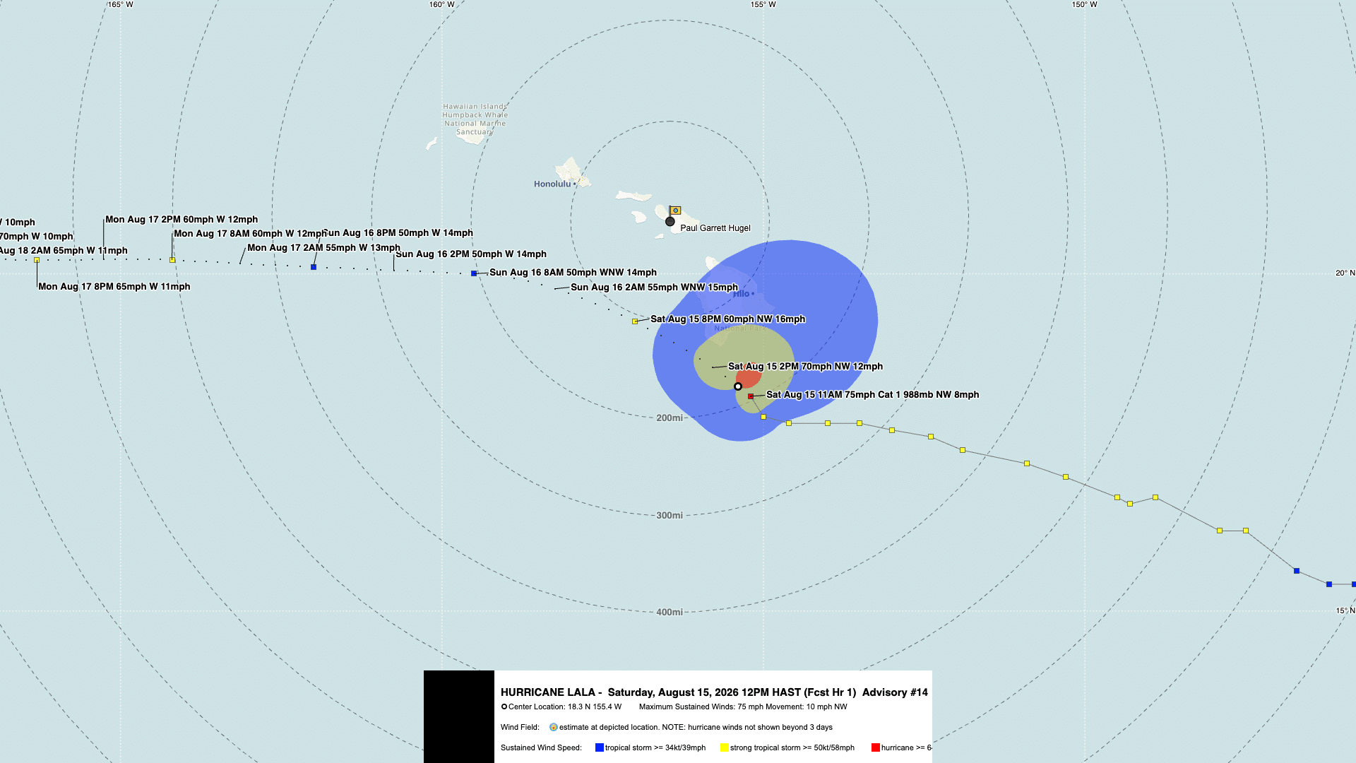
INIT  16/0900Z 19.6N 157.0W  65 KT  75 MPH
 12H  16/1800Z 20.1N 159.1W  60 KT  70 MPH
 24H  17/0600Z 20.5N 161.9W  55 KT  65 MPH
 36H  17/1800Z 20.5N 164.3W  55 KT  65 MPH
 48H  18/0600Z 20.4N 166.5W  55 KT  65 MPH
 60H  18/1800Z 20.3N 168.4W  55 KT  65 MPH
 72H  19/0600Z 20.4N 170.2W  60 KT  70 MPH
 96H  20/0600Z 21.5N 173.7W  65 KT  75 MPH
120H  21/0600Z 23.1N 176.1W  70 KT  80 MPH
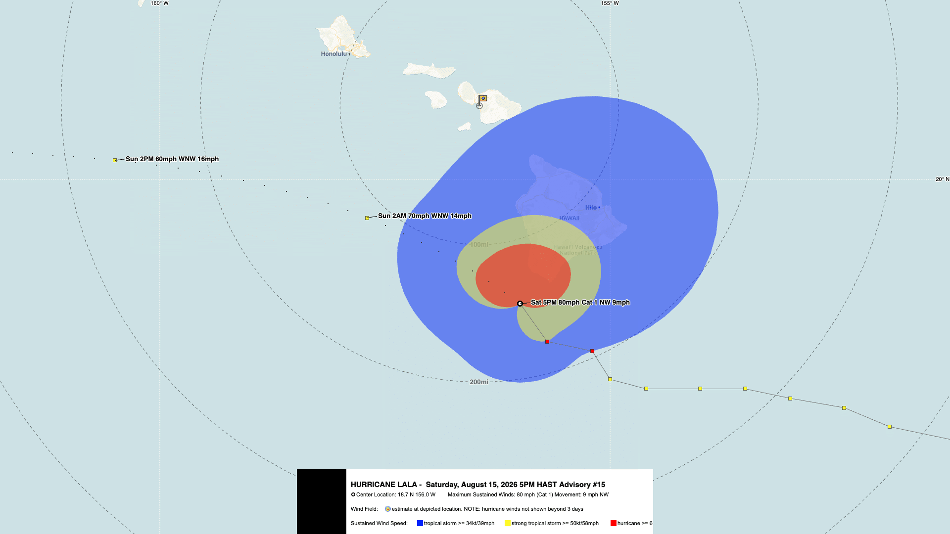
15 Aug 2026 – 5:00 PM HST
LALA’S EYEWALL BRUSHING THE SOUTHERN PORTION OF THE BIG ISLAND
DAMAGING WINDS AND HEAVY RAIN WILL PERSIST ACROSS THE BIG ISLAND THROUGH TONIGHT AND SPREAD WESTWARD ACROSS THE SMALLER ISLANDS ON SUNDAY
5:00 PM HST Saturday, August 15 position update:
- As of 5:00 PM HST Saturday, August 15, the center of Lala was located near 18.7°N, 156.0°W.
- Moving northwest at 9 mph.
- Minimum central pressure was 985 mb.
- Maximum sustained winds of about 80 mph.
Key Messages
- Damaging hurricane-force winds are expected to continue on the Big Island of Hawaii into the overnight hours, with the strongest wind gusts expected in areas of higher terrain. Residents are urged to stay in their shelter through tonight. Tropical-storm-force winds with gusts to near or up to hurricane strength will persist across portions of the smaller islands through Sunday.
- Heavy rainfall will continue over the Big Island this evening and then spread westward across the remainder of the island chain tonight and Sunday. This rainfall will produce life-threatening flooding and mudslides, especially in areas of steep terrain.
- Large and dangerous waves are expected to persist across portions of the Hawaiian Islands through the weekend. Surf is building along east-facing shores and will increase along exposed southern shores as Lala passes south of the islands. This heavy surf may cause localized coastal flooding and significant beach erosion.
Forecast Positions and Maximum Winds
INIT  16/0300Z 18.7N 156.0W  70 KT  80 MPH
12H   16/1200Z 19.6N 157.7W  60 KT  70 MPH
24H   17/0000Z 20.2N 160.5W  50 KT  60 MPH
36H   17/1200Z 20.3N 163.1W  50 KT  60 MPH
48H   18/0000Z 20.2N 165.1W  50 KT  60 MPH
60H   18/1200Z 20.1N 167.2W  55 KT  65 MPH
72H   19/0000Z 20.3N 169.0W  60 KT  70 MPH
96H   20/0000Z 21.5N 172.4W  65 KT  75 MPH
120H  21/0000Z 22.9N 175.2W  70 KT  80 MPH
15 Aug 2026 – 4:00 PM HST
HEAVY RAIN CONTINUES TO SPREAD ACROSS THE EASTERN MAIN HAWAIIAN ISLANDS
4:00 PM HST position update:
- As of 4:00 PM HST Saturday, August 15, the center of Lala was located near 18.6°N, 155.9°W.
- Moving northwest at 9 mph.
- Minimum central pressure was 988 mb.
- Maximum sustained winds of about 75 mph.
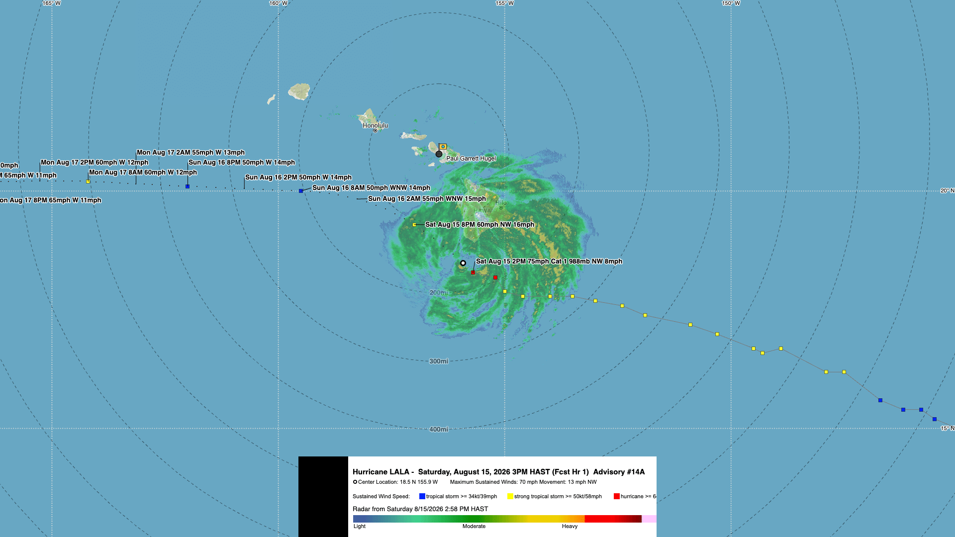
15 Aug 2026 – 3:00 PM HST
DAMAGING WINDS AND HEAVY RAIN SPREADING ACROSS THE BIG ISLAND OF HAWAII
3:00 PM HST (0100 UTC) position update:
- As of 3:00 PM HST Saturday, August 15, the center of Lala was located near 18.5°N, 155.7°W.
- Moving northwest at 8 mph.
- Minimum central pressure was 988 mb.
- Maximum sustained winds of approximately 75 mph.
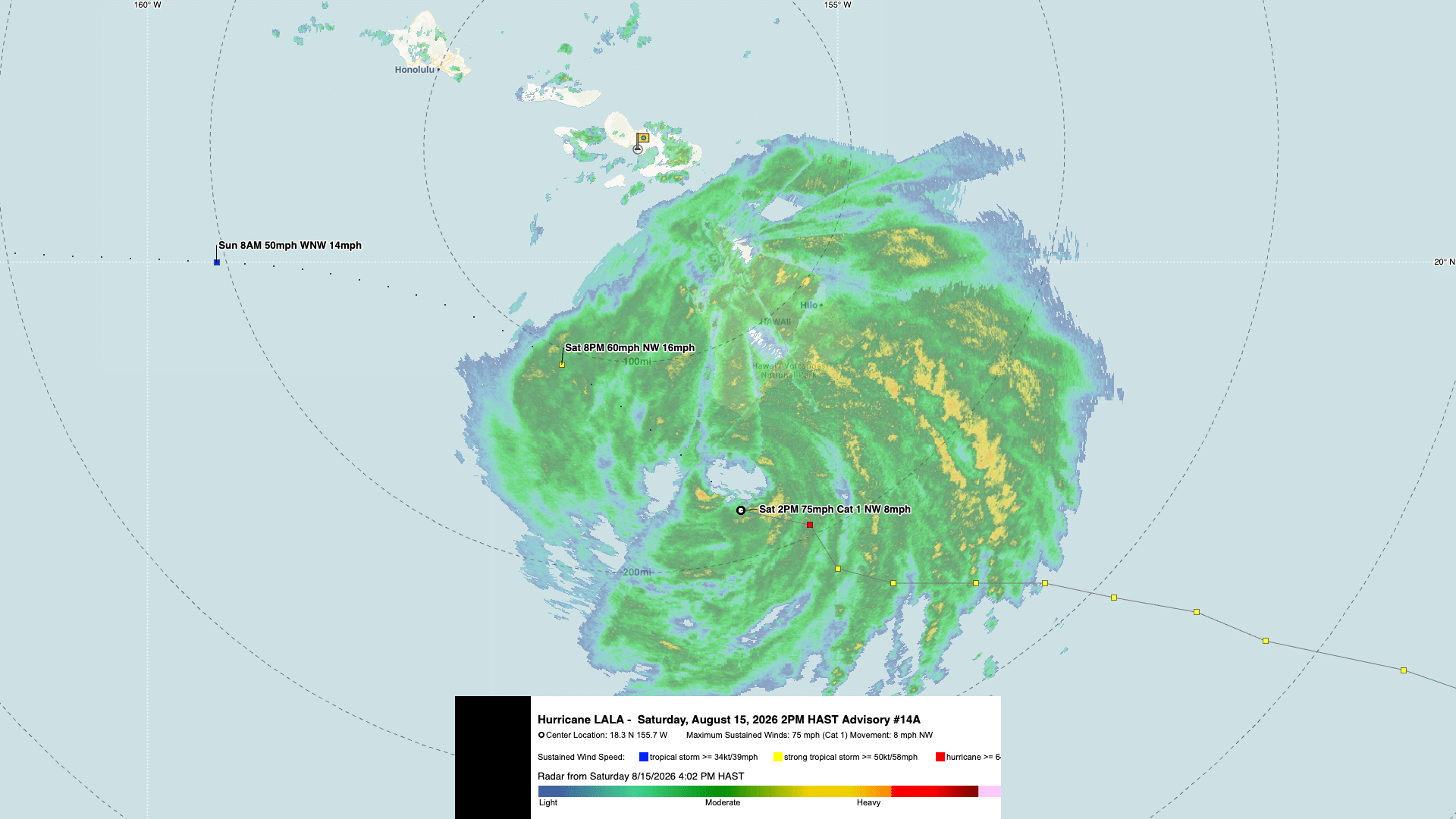
15 Aug 2026 – 2:00 PM HST
LALA CONTINUES NORTHWESTWARD AS IT INTERACTS WITH THE BIG ISLAND TERRAIN
DAMAGING WINDS WILL PERSIST ACROSS PORTIONS OF THE BIG ISLAND INTO TONIGHT AND SPREAD WESTWARD ACROSS THE SMALLER ISLANDS THROUGH SUNDAY
2:00 PM HST (0000 UTC) position update:
- As of 2:00 PM HST Saturday, August 15, the center of Lala was located near 18.3°N, 155.7°W.
- Moving northwest at 8 mph.
- Minimum central pressure was 988 mb.
- Maximum sustained winds of approximately 75 mph.
15 Aug 2026 – 1:00 PM HST
HEAVY RAINBANDS SPREADING ACROSS THE BIG ISLAND OF HAWAII
1:00 PM HST (2300 UTC) position update:
- As of 1:00 PM HST Saturday, August 15, the center of Lala was located near 18.3°N, 155.5°W.
- Moving northwest at 8 mph.
- Minimum central pressure was 988 mb.
- Maximum sustained winds of approximately 75 mph.
15 Aug 2026 – 12:00 PM HST
LALA CONTINUES TO BRING HEAVY RAINFALL AND GUSTY WINDS TO THE BIG ISLAND OF HAWAII
12:00 PM HST position update:
- As of noon Saturday, Aug. 15, the center of Lala was located near 18.2°N, 155.4°W.
- Moving northwest at 8 mph.
- Minimum central pressure was 988 mb.
- Maximum sustained winds of approximately 75 mph.
- 15 Aug 2026 at 22:00 UTC = 12:00 PM HST.
15 Aug 2026 – 11:00 AM HST
LALA STRENGTHENS INTO A HURRICANE AND INTERACTS WITH THE BIG ISLAND OF HAWAIʻI
11:00 PM HST position update:
- Location: 18.2°N, 155.2°W
- About 65 miles south-southeast of South Point, Hawaiʻi
- Maximum sustained winds: 75 mph
- Movement: Northwest at 8 mph
- Minimum pressure: 988 mb
- Hurricane Warning: Hawaiʻi County
- Tropical Storm Warning: Maui County, Oʻahu, and Kauaʻi County
The advisory warns of damaging hurricane-force winds, life-threatening flooding and mudslides, dangerous surf, rip currents, and coastal flooding. The next intermediate advisory is expected at 2:00 PM HST, followed by the next complete advisory at 5:00 PM HST.
Current Situation
As of August 15, 2026, Tropical Storm Lala was located southeast of Hawaiʻi and moving west-northwest toward the islands. The storm was producing strong winds and heavy rainfall, with the potential for conditions to worsen as it approached the Big Island.
In addition, forecast impacts may include:
- Heavy rain and life-threatening flash flooding
- Mudslides, especially in steep and mountainous areas
- Strong tropical-storm or hurricane-force winds
- Dangerous surf, large waves, and rip currents
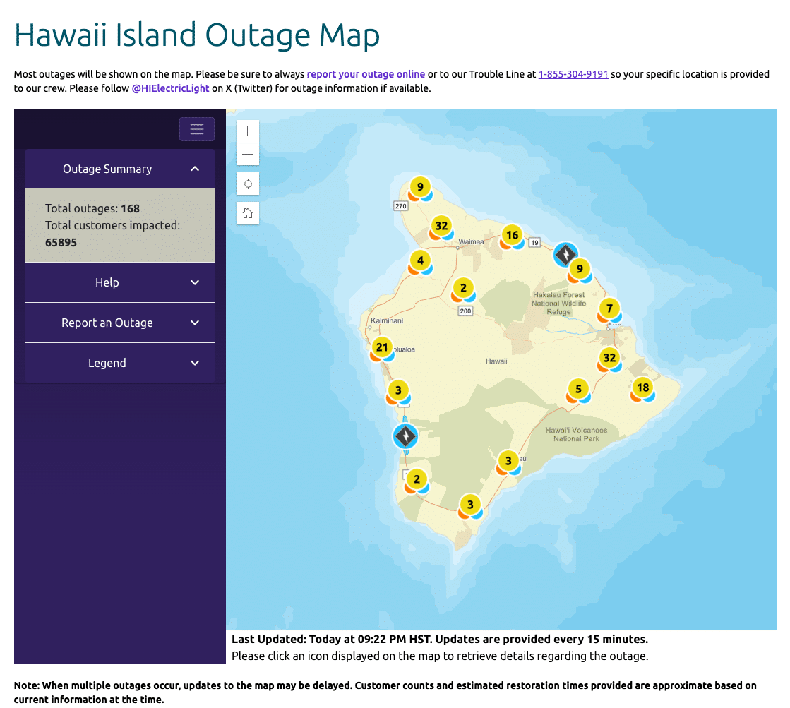
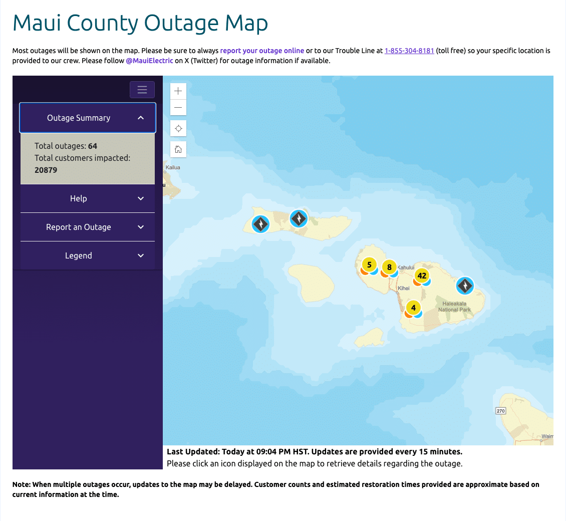
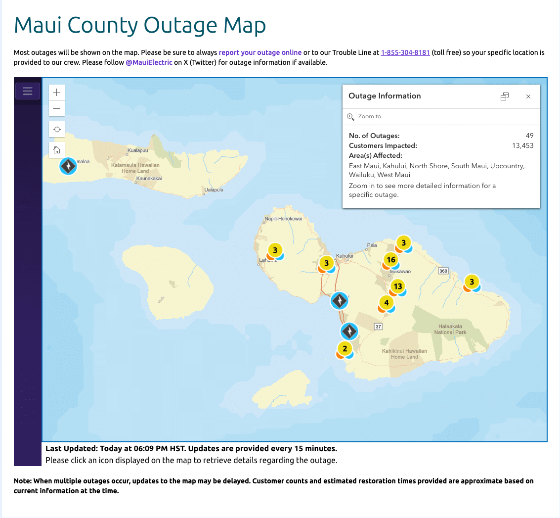
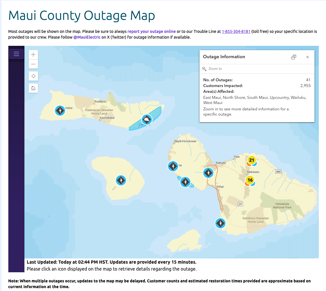
- Power outages and hazardous travel conditions
- Wildfire risk in areas affected by strong, dry winds
The strongest effects will depend on Lala’s exact track, intensity, and size. Conditions can change quickly, and impacts may occur well away from the storm’s center.
Live Satellite Imagery
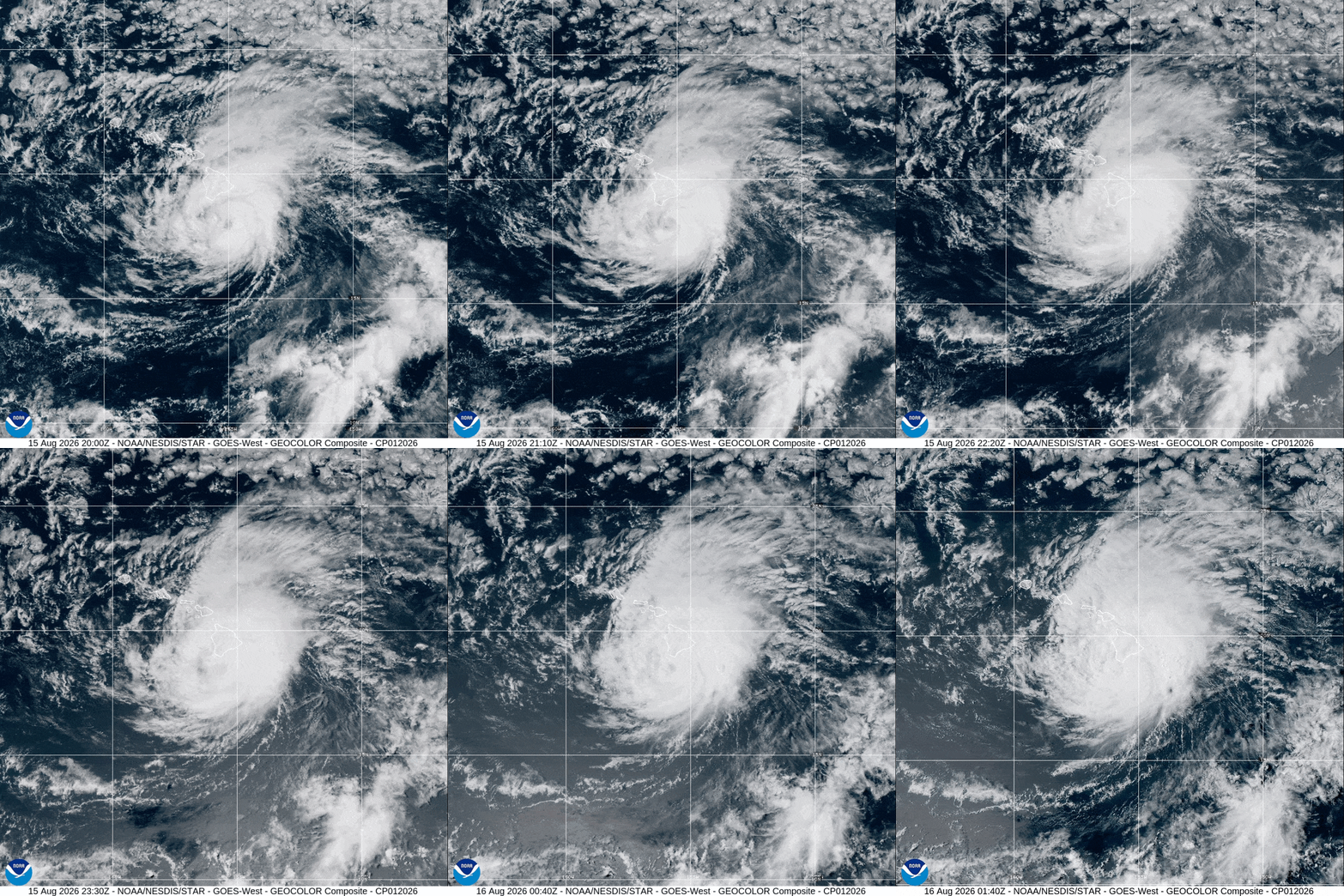
The satellite display uses NOAA GOES-West imagery covering the Pacific and Hawaiʻi region. The image shows cloud formations and storm activity from space, but it is not a substitute for official warnings, watches, forecasts, or emergency instructions.
Satellite imagery may also experience temporary delays or interruptions. For the most current information, consult the Central Pacific Hurricane Center, the National Weather Service Honolulu Forecast Office, and Hawaiʻi emergency management officials.
Stay Informed and Prepare
People in Hawaiʻi should review their emergency plans, secure loose outdoor items, charge phones and backup batteries, and be prepared for possible flooding or power disruptions. Those in flood-prone, coastal, or mountainous areas should pay close attention to evacuation guidance and local alerts.
Do not drive through flooded roads or attempt to cross fast-moving water. Never rely on satellite imagery alone when making safety decisions.
For official warnings and forecasts, visit:
- Central Pacific Hurricane Center
- National Weather Service Honolulu
- Hawaiʻi Emergency Management Agency
NOAA and CIRA provide this satellite imagery for informational purposes only. Do not rely on it as the sole basis for emergency, operational, or life-safety decisions.
The storm details above are time-sensitive and should be updated whenever a new official advisory is issued. The live image is broad-area satellite imagery, not a storm track or forecast cone.