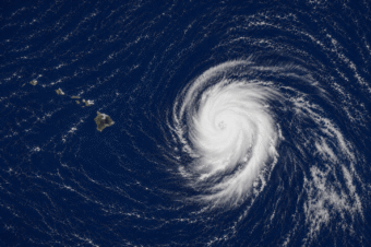
As of 5:00 a.m. HST on September 27, 2026, Hurricane Nolo was located about 260 miles southwest of South Point, Hawaii, moving west at 12 mph with maximum sustained winds of 105 mph. The storm is forecast to turn northwest and strengthen into a major hurricane by Monday before weakening, while staying south and southwest of the main Hawaiian Islands and approaching the Papahanaumokuakea Marine National Monument.
No coastal watches or warnings were in effect, though residents were advised to monitor the storm as watches could be issued for the marine monument area. Hazards included gusty winds across the islands, diminishing rainfall and storm surge threats, and dangerous surf and rip currents from swells affecting east- and south-facing shores of the Big Island.
Hurricane Nolo Advisory 28 Forecast +3 Hours 8:00AM HST


Live imagery: NOAA/CIRA GOES-West
Official sources: Below is the full Hurricane Nolo Advisory 28 bulletin exactly as the National Weather Service issued it. For the latest updates, see the Central Pacific Hurricane Center, the National Weather Service Honolulu, and Hawaii County Civil Defense. Earlier storm coverage on NKO.ORG: Tropical Storm Lala and Hurricane Erick Advisory 22.
BULLETIN
Hurricane Nolo Advisory Number  28
NWS Central Pacific Hurricane Center Honolulu HI   EP152026
Issued by NWS National Hurricane Center Miami FL
500 AM HST Sun Sep 27 2026

...NOLO SLIGHTLY STRONGER AS IT MOVES WESTWARD SOUTH OF THE
HAWAIIAN ISLANDS...


SUMMARY OF 500 AM HST...1500 UTC...INFORMATION
----------------------------------------------
LOCATION...16.2N 158.3W
ABOUT 260 MI...415 KM SW OF SOUTH POINT HAWAII
ABOUT 355 MI...570 KM S OF HONOLULU HAWAII
MAXIMUM SUSTAINED WINDS...105 MPH...165 KM/H
PRESENT MOVEMENT...W OR 270 DEGREES AT 12 MPH...19 KM/H
MINIMUM CENTRAL PRESSURE...967 MB...28.56 INCHES


WATCHES AND WARNINGS
--------------------
CHANGES WITH THIS ADVISORY:

None.

SUMMARY OF WATCHES AND WARNINGS IN EFFECT:

There are no coastal watches or warnings in effect.

Interests in the Hawaiian Islands should closely monitor the
progress of this system.  Watches may be required for portions
of the Papahanaumokuakea Marine National Monument later today.


DISCUSSION AND OUTLOOK
----------------------
At 500 AM HST (1500 UTC), the eye of Hurricane Nolo was located by
Air Force Reconnaissance aircraft near latitude 16.2 North,
longitude 158.3 West. Nolo is moving toward the west near 12 mph (19
km/h). A turn toward the northwest is expected by tonight, with this
general motion continuing through Tuesday.  On the forecast track,
the center of Nolo will remain well south and southwest of the main
Hawaiian Islands but will approach the Papahanaumokuakea Marine
National Monument early this week.

Maximum sustained winds have increased to near 105 mph (165 km/h)
with higher gusts.  Nolo is predicted to strengthen into a major
hurricane within the next day or so and reach its peak intensity by
Monday. Weakening is expected in a couple of days.

Hurricane-force winds extend outward up to 35 miles (55 km) from the
center and tropical-storm-force winds extend outward up to 150 miles
(240 km).

The estimated minimum central pressure is 967 mb (28.56 inches).


HAZARDS AFFECTING LAND
----------------------
Key messages for Nolo can be found in the Tropical Cyclone
Discussion under AWIPS header HFOTCDCP2 and WMO header WTPA42 PHFO.

WIND: Strong and gusty winds are possible for the main Hawaiian
Islands through today, although the core winds of Nolo will
stay to the south.

RAINFALL: Rainfall and flooding threats are diminishing across the
Big Island today with only scattered showers expected.  For
the eastern and southern portions of the Big Island, up to an
additional inch of rainfall is possible.   Across the remainder of
the Hawaiian Islands, no significant precipitation is expected.

STORM SURGE: The threat of significant storm surge has diminished,
yet water levels along the coast will remain elevated through
upcoming tide cycles due to persistent, dangerous wave action.

SURF: Swells generated by Nolo are affecting exposed east- and
south-facing shores of the Big Island and are expected to spread
westward and build through the weekend. These swells are likely
to cause life-threatening surf and rip current conditions. Please
consult products from your local weather office.


NEXT ADVISORY
-------------
Next complete advisory at 1100 AM HST.

$$
FORECASTER KATZ/PAPIN

NNNN